
Drones to Decisions: How Aerial Intelligence Is Transforming Agriculture
For generations, farmers have relied on experience, instinct, and physical observation to understand their land. A walk through the fields, a glance at leaf colour, the feel of soil moisture; these signals guided agricultural decisions across seasons. But agriculture today faces challenges far more complex than those of the past. Climate variability, unpredictable rainfall, pest outbreaks, and rising input costs make traditional monitoring increasingly insufficient.
Enter drones.
What began as experimental aerial tools has rapidly evolved into a powerful agricultural intelligence system. Modern agricultural drones do far more than capture images. They collect high-resolution data about crop health, soil conditions, irrigation patterns, and pest activity. When integrated with analytics platforms and GIS mapping tools, this data becomes actionable intelligence.
In India, where agriculture supports nearly half the workforce, drone-powered aerial intelligence is emerging as a critical technology for improving productivity, sustainability, and resilience.
India’s Drone Revolution in Agriculture
India’s drone ecosystem has expanded rapidly in recent years due to proactive government policies and industry innovation. The Government of India’s Drone Rules 2021 simplified licensing procedures and reduced regulatory barriers, making drone operations more accessible across sectors.
Alongside regulatory reform, the government introduced the Production Linked Incentive (PLI) scheme for drones and drone components, encouraging domestic manufacturing and technology development. According to the Ministry of Civil Aviation, these initiatives aim to position India as a global hub for drone technology.
Agriculture has emerged as one of the most promising applications.
According to the Ministry of Agriculture and Farmers Welfare, drones are increasingly used for crop monitoring, pesticide spraying, yield estimation, and soil analysis.
Industry analysts also estimate that India’s agricultural drone market will grow significantly over the next decade as precision agriculture practices expand across states.
From Drone Images to Agricultural Intelligence
The true value of agricultural drones lies not in aerial photography but in drone data analytics.
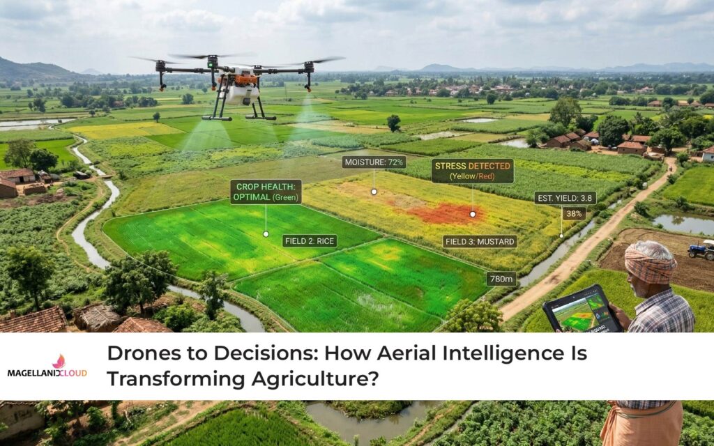
High-resolution cameras, multispectral sensors, and thermal imaging systems mounted on drones capture thousands of data points during a single flight. These sensors detect subtle variations in crop health that are invisible to the human eye.
When processed through AI-enabled analytics platforms, the data reveals patterns such as nutrient deficiencies, pest infestations, irrigation inefficiencies, and crop stress.
For example, multispectral imaging can detect early signs of plant stress weeks before visible symptoms appear. Farmers can then intervene earlier with targeted fertilisation or pest management, preventing yield loss.
According to research from the Food and Agriculture Organization (FAO), precision agriculture technologies, including drone monitoring can significantly improve crop productivity while reducing resource waste.
This transformation marks a shift from reactive farming to data-driven agriculture.
The Role of GIS Integration in Smart Agriculture
Drone data becomes even more powerful when integrated with Geographic Information Systems (GIS).
GIS mapping enables farmers and agricultural authorities to visualise drone data across geographic layers, including soil types, rainfall patterns, irrigation infrastructure, and crop distribution. This integration helps stakeholders analyse large agricultural landscapes rather than isolated fields.
Through GIS integration, drone-generated aerial intelligence can support:
- precision irrigation planning
- crop yield forecasting
- regional pest outbreak detection
- disaster damage assessment
According to the World Economic Forum, combining drone data with GIS and AI analytics enables more precise agricultural planning and climate-resilient farming systems.
For policymakers and agribusinesses, this means moving from scattered farm-level insights to region-wide agricultural intelligence.
Precision Farming: Doing More with Less
Agriculture faces increasing pressure to produce more food using fewer resources. Fertiliser costs are rising, water scarcity is intensifying, and environmental sustainability has become a global priority.
Drone-enabled precision agriculture helps address these challenges.
Instead of applying fertilisers and pesticides uniformly across entire fields, drones allow targeted intervention. Sensors identify exactly where crops require treatment, enabling farmers to apply resources only where needed.
According to the World Bank, precision agriculture technologies; including drone monitoring can reduce chemical usage while maintaining or increasing crop yields.
This targeted approach not only lowers operational costs but also reduces environmental impact.
Real-Time Monitoring for Climate Resilience
Climate uncertainty is one of the biggest threats facing Indian agriculture. Changing rainfall patterns, extreme weather events, and shifting pest cycles make traditional seasonal planning increasingly unreliable.
Drone-based aerial intelligence offers real-time monitoring capabilities that help farmers adapt quickly.
Drones can survey large agricultural areas within minutes, identifying waterlogging after heavy rainfall or drought stress during dry periods. Early detection allows farmers to implement corrective measures before crop damage becomes irreversible.
In disaster situations such as floods or cyclones, drone surveys help authorities assess crop damage rapidly and distribute relief more effectively.
The United Nations Environment Programme has highlighted drone monitoring as a valuable tool for climate-smart agriculture and environmental management.
Scaling Agricultural Intelligence in India
India’s agricultural landscape presents unique challenges for technology adoption. Farms are often fragmented, rural connectivity varies, and many farmers operate on tight budgets.
However, the scalability of drone services is improving through cooperative models, government programs, and agritech platforms that provide drone-as-a-service solutions.
Farmer producer organisations (FPOs), agri-startups, and state governments are increasingly deploying drone monitoring across clusters of farms rather than individual fields.
As drone analytics platforms mature, farmers will gain access not only to images but to decision-support systems, recommendations based on aerial intelligence, weather forecasts, and soil data.
This convergence of AI, drones, and data platforms is reshaping agriculture into a digitally integrated ecosystem.
The Role of Scandron and Magellanic Cloud
At Magellanic Cloud Limited (MCL), we believe the future of agriculture lies in transforming raw data into actionable intelligence.
Through Scandron, our drone and aerial intelligence vertical, we are working to bridge the gap between aerial data collection and real-world agricultural decision-making.
Scandron’s drone platforms capture high-resolution agricultural imagery using advanced sensors. These datasets are then processed through analytics frameworks that integrate AI, GIS mapping, and cloud infrastructure to generate meaningful insights.
By combining aerial intelligence with digital platforms, Scandron enables farmers, agribusinesses, and government agencies to monitor crop health, detect anomalies, and optimise resource usage.
Magellanic Cloud’s broader expertise in AI, data analytics, and digital infrastructure further strengthens this capability. Our integrated approach ensures that drone-generated data does not remain static imagery but evolves into strategic agricultural intelligence.
This vision aligns with India’s broader push toward technology-driven agricultural transformation.
From Observation to Intelligence
Agriculture has always relied on observation. Farmers watched the skies, the soil, and the crops to make decisions.
Today, that observation is moving into the air.
Drones provide a new vantage point over fields, farms, and landscapes. When combined with analytics, GIS systems, and AI models, aerial imagery becomes far more than photographs, it becomes insight.
The future of agriculture will be shaped not only by how crops grow but by how data flows across farms, markets, and policy frameworks.
Drone-powered aerial intelligence is helping farmers move from intuition to information, from reactive responses to predictive planning.
In a country where agriculture feeds millions and sustains livelihoods across rural communities, that shift matters.
From drones to decisions, the journey of agricultural innovation has truly taken flight.